8 Columbia River Gorge Waterfalls
Disclosure: This post contains some affiliate links. If you decide to make a purchase through my links, I will get a small commission at no cost to you. Any commissions directly support upkeep of this website and my print shop.
Introduction
The Columbia River begins in Alberta and winds through British Columbia and Washington where it then heads west along the Washington-Oregon border to the Pacific Ocean. Located just east of Portland, Oregon, the Columbia River Gorge is a canyon that spans a more than 80 mile stretch of this river. The Columbia River Gorge was established as a National Scenic Area in 1986 and covers nearly 300,000 acres. I tried to find an exact count of the number of waterfalls on the Oregon side of the gorge and came up with anything from 75-100 waterfalls! Many are unnamed and do not have easy access trails.
The gorge is a popular area for tourists, especially at the height of summer when an open parking space at many of the waterfalls is a rarity. We spent about a day and a half checking out waterfalls in the gorge during the July 4th holiday weekend back in 2016. It was busy! We ended up doing most of our hiking in the evening and morning. Early morning was the best time and we even had a couple of the waterfalls to ourselves.
Sadly, in October 2017, a destructive wildfire was ignited by someone illegally setting off fireworks during a burn ban. The fire, named the Eagle Creek Fire, burned nearly 50,000 acres. Some sections of hiking trails remain closed as of Dec. 2021 due to destruction from the fire, so be sure to check trail status before you visit.
In this post, I’ve detailed the 8 Columbia River Gorge waterfalls that we visited. Most of these require a small amount of easy hiking. The waterfalls are listed in the order in which we visited them. Conveniently, that is west to east.
Be sure to read to the end for recommendations on Columbia River Gorge books and maps.
Waterfalls highlighted
Latourell Falls
Shepperd’s Dell
Bridal Veil Falls
Multnomah Falls
Horsetail Falls & Ponytail Falls
Elowah Falls
Wahclella Falls
Latourell Falls
Parking coordinates: 45.53883, -122.21777
Trail length: 0.2 mi/0.32 km RT
Latourell Falls is the first, main waterfall just east of Portland, as you enter the gorge. It plunges 224 ft over a beautiful wall of columnar basalt. There are a couple of nice spots to photograph the falls from. One is an upper viewing area where you can frame the falls with the trees from the trail. The second spot is near the base of the falls, where you can walk around for multiple angles. It can be difficult to get a photo without a person in it unless you visit very early in the day.
35mm, ISO 100, f/22, 1/6 sec
17mm, ISO 100, f/22, 1/8 sec
Shepperd’s Dell Falls
Parking coordinates: 45.54692, -122.19757
This is a quick roadside stop where you can photograph the bridge spanning the dell as well as the falls. The waterfall cascades down the mountain for more than 200 feet in a series of plunges. Only a small portion of the falls is visible via the path down from the bridge. I much preferred the view of the bridge vs the falls itself.
17mm, ISO 100, f/16, 1/6 sec
17mm, ISO 100, f/5.6, 1/60 sec
Bridal Veil Falls
Parking coordinates: 45.55363, -122.18284
Trail length: 0.5 mi/0.8 km RT
Bridal Veil Falls has 2 drops over a total of 118 feet. It’s hard to do this waterfall justice with a photo. In particular, I wish I would have taken a photo with myself or Jess in it to show scale. It’s much taller than it looks in this photo. I believe this is the only falls that is actually on the Columbia River side of the Historic Columbia River Highway, rather than on the mountain side of it. I recommend visiting it in early morning or when it’s cloudy, if possible. We visited in early evening and the sun was still shining through the trees, which made getting even light on the waterfall and surrounding foliage more challenging.
24mm, ISO 100, f/16, 1 sec
Multnomah Falls
Parking coordinates: 45.57774, -122.11746
Trail length: 0.4 mi/0.64 km RT to lower viewing area
0.8 mi/1.29 km RT to bridge
Here it is — the famous Multnomah Falls. This is the most renowned waterfall in the Columbia River Gorge. At a total height of approximately 620 feet, it is the tallest waterfall in Oregon. On any given day, you will see crowds of people photographing the falls. There are two main viewing areas to photograph the falls from. The lower viewing area (pic below) gives you the classic view of the falls and the Benson Bridge. There is a path that goes across the Benson Bridge and up the mountain to the top of the falls. We stayed at the lower viewing area.
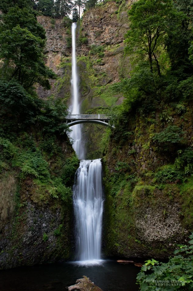
24mm, ISO 100, f/16, 1/2 sec
Horsetail Falls & Ponytail Falls
Parking coordinates: 45.59029, -122.0685
Trail length: 0.9 mi/1.45 km RT
I loved this hike to Ponytail Falls. The trail starts at Horsetail Falls which drops about 200 feet into a pool. The trail to Ponytail Falls is a little over 0.4 miles one-way and does climb uphill a bit. It’s worth the short climb! Ponytail Falls is a beautiful waterfall that drops about 88 feet. The stream continues down the mountainside to Horsetail Falls. The unique feature of Ponytail Falls is that you can walk behind it underneath a rocky overhang. The level of green around this waterfall was off the charts, making it feel very Pacific Northwesty.
Horsetail Falls
16mm, ISO 100, f/22, 1/2 sec
Ponytail Falls
16mm, ISO 100, f/22, 1 sec
Ponytail Falls
16mm, ISO 100, f/20, 1.6 sec
Ponytail Falls
16mm, ISO 100, f/22, 0.8 sec
Ponytail Falls
16mm, ISO 100, f/22, 1.3 sec
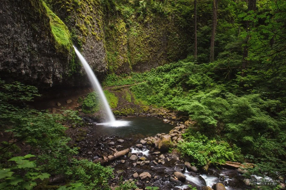
Elowah Falls
Parking coordinates: 45.6124, -122.00426
Trail length: 1.2 mi/1.93 km RT
Elowah Falls is formed from McCord Creek and plunges more than 200 feet over a shelf-like alcove. Photographically speaking, this photo of Elowah Falls ended up being my favorite capture in the Columbia River Gorge. We started this hike early in the morning and when we arrived at the falls, we didn’t see anyone else. I was able to hop around to different boulders in the stream, photographing the falls from various angles, without anyone walking into frame. This was one of those waterfalls that I could have watched for hours.
Buy print
16mm, ISO 100, f/22, 0.6 sec
Wahclella Falls
Parking coordinates: 45.63061, -121.95388
Trail length: 1.9 mi/3.06 km RT
Wahclella Falls is a beautiful two-tiered falls that is about 130 ft tall. The upper tier is not fully visible, but with the right angle you can get a peek of it. There are a few photographic angles to pick from at this falls. The three main ones are from the bridge over the stream to the right of the falls (first photo below), a hill with a view looking down (second photo below), and down among the rocks along the stream. Similar to my experience with Bridal Veil Falls, it was hard for me to do this falls justice in a photo. The biggest challenge we had at this falls was avoiding people — we didn’t arrive here until about 10:30am. Unfortunately, this limited opportunities for some photos.
Look closely in the middle of the photo for a tiny human that I decided not to edit out. The falls looks much bigger with the scale reference!
25mm, ISO 100, f/22, 1/5 sec
16mm, ISO 100, f/22, 1/3 sec
Summary
We were able to cover several waterfalls during our day and a half in the gorge, but we barely scratched surface! If I had to pick a favorite waterfall out of the ones we saw, I think Elowah Falls would be tied with Ponytail Falls.
Thanks for reading!
My Favorite Books and Maps for Planning a Trip to the Columbia River Gorge
Below is a list of what I found to be the best books and maps for planning our trip to the Columbia River Gorge. Amazon links are provided.
Photographing Oregon by Greg Vaughn and Laurent Martres
Day Hiking Columbia River Gorge by Craig Romano
Hiking Waterfalls in Oregon by Adam Sawyer
Mount Hood, Columbia River Gorge Map Pack by National Geographic Maps


